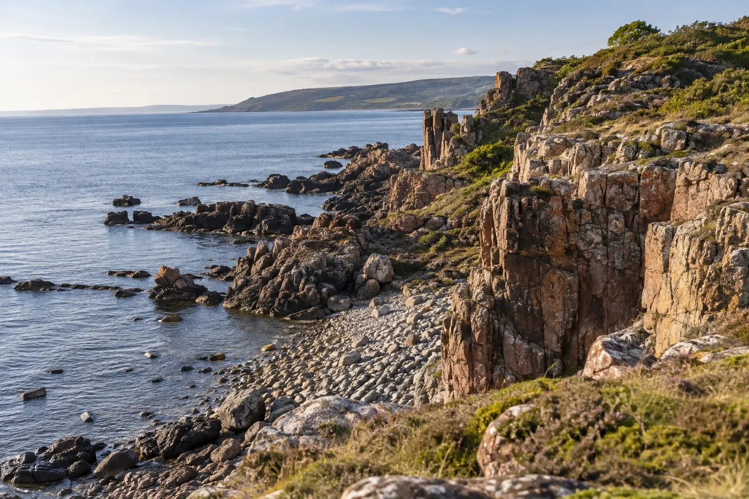
The Bjäre peninsula packs red cliffs, Bronze Age graves, seal rocks and a car-free island into Skåne’s north-west corner. Most of the best coast is nature reserve, and each reserve has its own rulebook.
When you need this
- You’re driving the E6 between Helsingborg and Halmstad and want a day on the coast
- You want to walk to Hovs hallar or along Skåneleden around the peninsula
- You’re planning a day on Hallands Väderö and need the boat season and the island’s bans
- You want to camp, sleep in a shelter or park a motorhome overnight
- You’re bringing a dog to the beach in summer
- You’re coming for the tennis week in July, or arriving by train and wondering where the station went
The peninsula at a glance
The Bjäre peninsula (Bjärehalvön) juts into the Kattegat at Skåne’s north-west corner, between Laholm Bay to the north and Skälderviken bay to the south. Across Skälderviken you see Kullaberg. The whole peninsula is Båstad municipality, and its eastern edge is the wooded ridge of Hallandsåsen, whose northern slopes run down to Båstad, the main town. The sea here sits in the transition zone between the North Sea and the Baltic, so its salinity swings with wind and currents — one reason seals, porpoises and seabirds come to feed.
Båstad is old: it first appears in a letter of purchase from 1450, and visitors began arriving in numbers after the railway from Helsingborg opened in 1885. Torekov, at the western tip, is a former fishing village with 19th-century fishing huts and the harbor for the island boat.
| Place | What it is |
|---|---|
| Hovs hallar | Red gneiss cliffs, shingle fields and sea stacks at the north tip; nature reserve |
| Knösen | The peninsula’s high point, 154.7 m, a steep climb on Skåneleden |
| Gröthögarna | Eight Bronze Age burial cairns in a row between Hovs hallar and Torekov |
| Dagshög | Skåne’s largest burial mound, 5 m high and 42 m across, south of Torekov |
| Hallands Väderö | A 3 km island reserve off Torekov: old woodland, meadows, seals, a lighthouse |
| Englandsdal | A fault valley on Hallandsåsen with rock walls up to 30 m |
| Norrvikens trädgårdar | A garden attraction west of Båstad, begun in the early 1900s, now seven gardens |
Hovs hallar and the north coast
The north coast is protected as the Bjärekusten nature reserve (formed 1971, 328 hectares), run by the county board, Länsstyrelsen Skåne. Its centerpiece, Hovs hallar, is a cliff coast of reddish bedrock gneiss with scree slopes of angular blocks, shingle fields of sea-rounded stones (klapperstensfält), sea stacks (raukar) and cave-like formations. On the plateau above, juniper pasture opens out over Laholm Bay.
From the main car park on Hovshallavägen a stony, in places steep path drops to the shore. The county board says getting down can be a little difficult, and the municipality doesn’t recommend Hovs hallar as a bathing spot for families with small children. It’s a place for cliff swimming and snorkeling; there are toilets at the main car park.
Walking west, the land flattens into grazed shore meadows. Seals often rest at Norrebrohamn, and further on you pass Gröthögarna. On stormy days, birders crouch on the cliffs for Atlantic seabirds blown in — storm petrels and gannets among them. On spring evenings, natterjack toads call at Norrebrohamn and Ilasjön.
Skåneleden runs through the whole reserve. Stage 16, Båstad to Hovs hallar, is 16 km and graded red, the trail’s hardest grade: loose or slippery ground with steep sections where you may need your hands. It climbs Hallandsåsen’s north slope through Englandsdal’s fault valley and up to Knösen. Stage 17, Hovs hallar to Torekov, is 8 km, graded blue and takes two to three hours — the easy choice. Our Skåneleden guide covers the whole trail.
To spread the crowds, use the smaller access points: Krossarevägen in Kattvik (nearest Knösen), Norrebrohamn, Dalen, Ängalag (nearest Gröthögarna, with toilets), Svarta hallar and Varan by Torekov.
Torekov and the south coast
South of Torekov, the Södra Bjärekusten reserve runs about 15 km to Vejbystrand: flat coastal heath, shingle, sandy coves and a view across Skälderviken to Kullaberg. Harbor seals and porpoises are seen most often in the south, around Vistorps hamn, and sometimes grey seals too. Dagshög, Skåne’s largest burial mound, stands near Torekov. Skåneleden stage 18, Torekov to Vejbystrand, covers it in 20 km and five to six hours, with bus stops at both ends.
Two things catch kayakers and campers here. The islets of Inre and Yttre Gryteskär at the southern end, and marked water around them, are closed from 1 March to 30 June. And all tent camping inside the reserve is banned — but just outside it, by the Gryteskär camp site, a wind shelter allows overnight stays, tents included. See landing rules on islands and skerries for how protected areas work at sea.
Hallands Väderö: a day island with strict rules
Hallands Väderö is a 3 km island off Torekov and one of Skåne’s larger nature reserves (formed 1998, 1,834 hectares including the surrounding sea). It has old broad-leaved woodland with rare beetles and lichens, alder carrs, grazed meadows, swimming from rocks and a little sand, a summer kiosk, and an outdoor museum in the old pilot’s cottage, Lotsstugan, open daily from spring to autumn. Harbor seals haul out on the rocks around it; the colony has grown since the species was protected in the 1960s.
The boat. Väderötrafiken runs from Torekov harbor to Sandhamn on the island, with some summer trips from Båstad. In 2026 the season ran from 3 April to 25 October: daily from 30 May to 6 September, otherwise weekends and holidays. Outside the season you book a trip. Fares are in the Practical information table below.
What the island bans. The county board’s regulations are unusually strict for a day-trip island:
| Banned on Hallands Väderö | Why it matters |
|---|---|
| All outdoor fires, including spirit and gas stoves, storm cookers and grills | Stricter than a national fire ban, under which stoves stay legal; bring a packed lunch |
| Tents and any overnight stay outdoors | Plan for the last boat back |
| Cycling and mountain biking | The boat doesn’t take bikes either |
| Loose dogs | Dogs travel free on the boat, on a lead on the island |
| Pulling boats up on sandy beaches, anchoring in Sandhamn bay | Own-boat visitors anchor elsewhere along the coast |
| Entering the seal area between the island and Sandskär and Svarteskär | Closed all year |
| Entering marked bird islets and skerries | Closed 1 April to 15 July |
Fishing is exempt from the ban on catching animals. In 2026 the last regular boat back left Sandhamn between 15:20 and 17:20 depending on the season — miss it and there’s nowhere you may legally sleep. Our seals guide explains the protection areas.
Båstad’s beaches and the dog rule
Båstad’s beaches are long, shallow and sandy: Skansenbadet in town (about 300 m, with showers and changing huts), Malens havsbad (just over 1 km), Hemmeslöv at the Stensån river mouth, where the sand beach towards Halmstad begins, and Torekov (about 600 m, plus the old morning-swim jetty). Hovs hallar, Rammsjöstrand and Ydrehall are rocky. Winter swimmers find ladders year-round at Torekov, Glimminge plantering and Skansenbadet. For the coast north of the municipal border, see our Halland coast guide.
The dog rule is time-based. From 1 May to 15 September, dogs may not be on municipal beaches — sand, water or jetties — between 08:00 and 18:00. Outside those hours they’re welcome, though never on the bathing jetties.
| Dog beach (open all year, signed) | Where |
|---|---|
| Båstad | From the Stensån mouth 150 m north; park at the end of Måsvägen |
| Segelstorps strand | A signed stretch north of Vistorps hamn |
| Torekov | Bläsingestranden, from Andrebäck 150 m north |
In nature reserves dogs must be leashed at all times, and that includes the beaches at Stora Hult, Glimminge plantering and Segelstorp. Everywhere else in nature, the national rule applies from 1 March to 20 August — see dogs in nature. Horses may be ridden on municipal beaches only from 16 September to 30 April.
Bathing water can be affected after cloudbursts and strong winds. The municipality samples its beaches and publishes the results through the marine agency HaV’s bathing-water service.
The tennis week
Every July, Båstad hosts a clay-court tournament at its tennis stadium: a women’s week followed by a men’s ATP 250 week. In 2026 the men’s event ran from 13 to 19 July. For 2027 the organizers have already announced 5–10 July and 11–18 July, the 79th edition. The town fills up; on big-event days the municipality sends visitors to the Prästliden car park on Italienska vägen. See watching sports in Sweden.
Where you can sleep, cook and park
| You want to… | On Bjäre |
|---|---|
| Pitch a tent | Not in Bjärekusten, Södra Bjärekusten, Hallands Väderö or Englandsdal. Free option: the Gryteskär shelter, just outside the southern reserve. Otherwise a campsite, or allemansrätten (the right of public access) on non-reserve land away from homes and farmland |
| Make a fire or use a stove | No fires in Bjärekusten (there’s no designated place); Skåneleden has a shelter with a fire place just outside the reserve by Hovs hallar. On Hallands Väderö no stoves or grills at all |
| Sleep in a motorhome | Not at Bjärekusten’s access car parks 00:00–06:00, nor anywhere in Södra Bjärekusten, including the Gryteskär car park. In Båstad, designated motorhome spaces at Prästliden and Malenbadet — read the signs |
| Park | Designated car parks only in reserves; some municipal car parks charge 1 June–31 August |
Breaking a reserve regulation is an offence that can be fined. For the national picture, see motorhome wild camping, wild camping and camping stoves during fire bans.
Getting there and around
The station has moved. Since December 2015, trains have run through the 8.7 km Hallandsås tunnel instead of over the ridge. The station serving Båstad today lies north of the tunnel and replaced the old station in town — Skåneleden’s Båstad stage now begins “close to the old railway station”. A second new station opened at Förslöv on the south side. Öresundståg, the Copenhagen–Gothenburg regional train, stops at Båstad; check the connecting bus into town in the journey planner. Our Öresundståg guide covers tickets.
Buses inside the municipality are Skånetrafiken’s; northbound journeys use Hallandstrafiken, and within Båstad municipality a Skånetrafiken ticket is valid on Hallandstrafiken’s buses. Torekov and Vejbystrand have bus stops. Villages without regular lines are served by närtrafik, pre-booked trips shown with a phone icon in Skånetrafiken’s planner — see Skåne public transport. The nearest airport, Ängelholm–Helsingborg, is about 25 km from Båstad.
By bike, Kattegattleden’s 55 km Ängelholm–Båstad stage crosses the peninsula and is the route’s hilliest.
Practical information
| Item | What to know (checked 15 October 2026) |
|---|---|
| Nature reserves, municipal beaches | Free |
| Boat to Hallands Väderö, 2026 regular fare | Adult return 250 kr, single 150 kr; child 4–14 return 170 kr; under-4s free but must be booked; family (2+2) 790 kr; dogs and pushchairs free; no bikes |
| Boat season 2026 | 3 April–25 October; daily 30 May–6 September, otherwise weekends and holidays; last return 15:20–17:20 |
| Parking | Free at many car parks; some municipal ones charge 1 June–31 August, price on the sign |
| Skåneleden on Bjäre | Stage 16 Båstad–Hovs hallar 16 km (red); 17 Hovs hallar–Torekov 8 km (blue); 18 Torekov–Vejbystrand 20 km (blue) |
| Tennis 2027 | Women’s week 5–10 July, men’s ATP 250 11–18 July |
| Bus and train fares | Skånetrafiken and Öresundståg apps; set by the operators |
FAQ
How do I get to Hallands Väderö?
By the boat from Torekov harbor to Sandhamn on the island; in summer some trips also leave from Båstad. In 2026 boats ran from 3 April to 25 October, daily from 30 May to 6 September and at weekends otherwise. Buy tickets online or at the kiosk by the boats. Bikes are not carried, and cycling is banned on the island.
Can you camp on the Bjäre peninsula?
Not in its coastal nature reserves: tents are banned at Hovs hallar, along Södra Bjärekusten, on Hallands Väderö and in Englandsdal. The legal free option is the wind shelter at Gryteskär, just outside the southern reserve, where you may sleep and pitch a tent. Elsewhere allemansrätten applies away from homes and farmland, and the peninsula has campsites.
Can I bring my dog to the beach in Båstad?
Yes, outside the summer daytime ban. From 1 May to 15 September dogs may not be on municipal beaches, in the water or on jetties between 08:00 and 18:00. Three signed dog beaches, at Båstad’s Stensån mouth, Segelstorps strand and Torekov’s Bläsingestranden, are open all year. In nature reserves dogs must be leashed at all times.
Is Hovs hallar suitable for children?
For a walk on the clifftop, yes; for swimming, less so. The path down to the stony shore is steep in places, and the municipality does not recommend Hovs hallar as a bathing place for families with small children. Shallow sandy beaches such as Skansenbadet, Malen, Hemmeslöv and Torekov suit young children better, and most have toilets and jetties.
When is the tennis tournament in Båstad?
Every July, on clay at the tennis stadium in Båstad, with a women’s week followed by a men’s ATP 250 week. In 2026 the men’s event ran from 13 to 19 July. For 2027, the organizers have announced 5–10 July and 11–18 July, the tournament’s 79th edition. Expect full car parks; the municipality directs event visitors to Prästliden.
Can I sleep in my motorhome at Hovs hallar?
No. Bjärekusten’s regulations ban parking a motorhome, campervan or similar vehicle at the reserve’s access car parks between 00:00 and 06:00, and Södra Bjärekusten bans it throughout the reserve, including the Gryteskär car park. In Båstad, the municipality points motorhomes to designated spaces at the Prästliden car park and at Malenbadet; read the signs there.
Is there a train station in Båstad?
Yes, but not in the old center. Since the Hallandsås rail tunnel opened in December 2015, trains have stopped at a station north of the tunnel that replaced the old one in town, and a second station opened at Förslöv on the south side. Öresundståg stops at Båstad; check the connecting bus into town in the journey planner.
Related guides
- Kullaberg — the cliffs across Skälderviken, with porpoises and their own reserve rules
- Skåneleden — the trail that follows Bjäre’s coast, stage by stage
- Halland coast and Varberg — the sand beaches that start where Båstad’s end
- Nature reserves in Sweden — why every reserve here has a different rulebook
- Skåne — the rest of the region, from Malmö to Österlen
Facts verified 15 October 2026. Sources: Länsstyrelsen Skåne, Båstads kommun, Skåneleden (Region Skåne), Väderötrafiken, Skånetrafiken, Öresundståg, Naturvårdsverket, Nordea Open and the ATP Tour — full register in this topic’s source file. Found something outdated? Tell us and we’ll fix it.