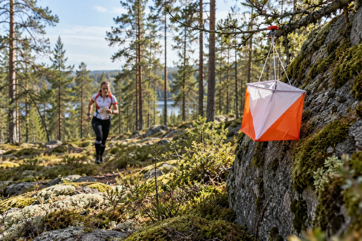
That small orange-and-white marker by a boulder in a Swedish forest is an orienteering checkpoint. Here is how the sport works, how to read the map, and the four ways a visitor can try it, from a free app to a 15,000-runner race week.
When you need this
- You see a small orange-and-white marker or a Hittaut post in a Swedish forest or park
- You want a free, self-paced outdoor activity in a Swedish town
- A Swedish friend or colleague invites you to an orienteering event
- Your family wants an outdoor sport with courses for small children
- You are planning a summer trip around O-Ringen in July 2027
What orienteering is
Orientering is a race, or a walk, between checkpoints (kontroller) marked on a special map. You visit them in a set order but choose your own route. In the terrain each checkpoint is an orange-and-white marker (skärm) placed at the feature in the center of the circle on your map: a boulder, a path junction, a small cliff.
Sweden takes it seriously. The Swedish Orienteering Federation (SOFT) counts more than 500 clubs, and the country hosts O-Ringen, which calls itself the world’s biggest orienteering event. Orienteering also comes in four disciplines: on foot, on skis, on mountain bikes, and precision orienteering.
Four ways to try it
| Option | What it is | Cost | Best for |
|---|---|---|---|
| Hittaut | Permanent checkpoints around 96 towns, May–October, found with app or paper map | Free | A first taste, any pace, any time of day |
| Motionsorientering | Simple open event in 200+ towns; sign up on site, instructor present | Small fee, cash or Swish | Your first “real” course |
| Open classes (öppna klasser) | Courses for anyone at ordinary competitions; no club needed | Entry fee | Trying a race atmosphere |
| O-Ringen | Five-stage race week; Stockholm, 25–31 July 2027 | Entry fee, cheaper early | A summer trip built around the sport |
Hittaut is the obvious start. Local clubs set out checkpoints for the season, coordinated by SOFT, and you find them on foot, by bike or running, around the clock. Download the app or pick up a paper map at a distribution point (utlämningsställe). Each checkpoint carries a letter code you register on your account, which enters you in a prize draw. Checkpoints are graded green (very easy), blue (easy), red (intermediate) and black (advanced), and accessible ones are marked on the map and filterable in the app.
Check the town list first. In 2026 it included Stockholm (City/Järva and Upplands Väsby), Gothenburg and Uppsala, but not Malmö, where the nearest area was Trelleborg/Vellinge. The season usually ends in October; a few towns have run a December winter edition.
Motionsorientering is the next step: at least four courses, from about 2–2.5 km up to more than 5 km, with an instructor on site to answer questions before you start. Payment is cash or often Swish, and Swish needs a Swedish bank account, so bring cash. Veckans bana (“the week’s course”) is a quieter option: checkpoints stay out for a week or more, you print the map yourself and usually pay by Swish.
Reading the map
An orienteering map is not a hiking map. It follows an international standard with its own color code, and the first thing to unlearn is that white means open ground.
| Color on the map | Means |
|---|---|
| White | Open, easy-running forest |
| Light green | Denser forest that slows you down |
| Yellow-orange | Open land |
| Dotted yellow-orange | Cultivated land; do not enter |
| Olive green | Forbidden area |
| Blue | Water |
| Brown lines | Contours (height) |
| Black | Rocks, paths, buildings |
The course itself uses three symbols: a triangle for the start, numbered circles for checkpoints, and a double circle for the finish. Maps are usually 1:10,000 or 1:7,500; sprint races use 1:4,000 or 1:3,000. To get meters per centimeter, strike the last two zeros of the scale: at 1:10,000, 1 cm is 100 m.
Set the map to north (passa kartan) and keep it that way as you turn. All text on the map is written with north at the top, so if you can read it the right way up, map north is ahead of you. To take a compass bearing:
- Lay the compass edge from where you are to where you are going, direction arrow pointing to the target.
- Hold map and compass flat with the direction arrow straight ahead.
- Turn your whole body until the red end of the needle matches map north, then aim at a tree in that direction and walk to it.
Most orienteers now use a thumb compass, but SOFT says a baseplate compass works just as well. The classic mistake is reading the map upside down and heading 180 degrees wrong (kontrakurs).
Your first event, step by step
- Find an event. Look up the local club or district on Svensk Orientering, or check Eventor, the federation’s calendar for all Swedish competitions.
- Register on site. Choose a course by length and difficulty and say whether you want timing.
- Pay in cash unless you have Swish, and borrow a punching chip if you have none.
- Dress for scratches. Long trousers and shoes with grip; a compass helps but is not required at motionsorientering.
- Punch every checkpoint in number order. The code number on the marker confirms you are at the right one.
- Read out your chip at the finish (stämpla ut), even if you gave up.
Rules that catch newcomers
- Always read out at the finish. Organizers use the read-out to confirm everyone is back from the forest safely.
- Full-cover clothing at competitions. No bare skin on legs or torso, though a T-shirt with long trousers is fine. The rule dates from a 1962 hepatitis (gulsot) outbreak among orienteers spread through scratches.
- Forbidden areas mean forbidden. Gardens, fields with growing crops, railways and marked wildlife zones are shown on the map and taped in the terrain.
- Following is for open classes only. Tagging along behind another runner is banned in age classes but allowed in open classes.
- Leave checkpoints alone. Under the right of public access, organizers may put out checkpoints for a short training or race without the landowner’s consent. Naturvårdsverket’s guidance says each should carry the organizer’s name, a phone number and a removal date. Do not take or move one. Our guide to allemansrätten explains the wider right.
Competition courses use six difficulty levels: green, white, yellow, orange/red, violet and blue/black. Hittaut’s green-blue-red-black grades are a separate scale, so do not mix them up.
O-Ringen 2027
O-Ringen has run every summer since 1965, traditionally in week 30, with 15,000 to 20,000 participants from about 40 countries and ages from 2 to 98. Gothenburg hosted the 60th edition, which ended on 25 July 2026. In 2027 it comes to Stockholm, 25–31 July.
You do not need to be a club runner. Alongside the age classes there are five- and three-day open classes (with an option to run without timing), single-stage entries (etappstart) and Inskolning, a beginner class for children up to 16 where everyone gets a prize. The youngest can try Miniknat, a playful taped mini-course, and the organizer offers childcare. Training maps at Ågesta and Djurgården open beforehand. Entry is online and fees step up over time: the first discount deadline is 1 November 2026.
Where it came from
Most retellings say orienteering became civilian in 1919. SOFT’s own history is more precise:
| Year | What happened |
|---|---|
| 1886 | The word orientering first used for map exercises at the Karlberg military academy |
| 1893 | Officers race it at the Stockholm garrison sports day, 28 May |
| 1897 | First civilian race anywhere, near Oslo, Norway |
| 1901 | Sweden’s first civilian race, Sundbybergs IK, 17 March |
| 1919 | Ernst Killander’s race at Saltsjöbaden sets the modern format; he becomes “the father of orienteering” |
| 1938 | Swedish Orienteering Federation founded, 6 January |
| 1965 | First five-day race, the start of O-Ringen |
Practical information
| Item | Detail |
|---|---|
| Hittaut | Free; 96 towns in 2026; usually May–October; app or paper map |
| Motionsorientering | 200+ towns; at least four courses; small fee, cash or often Swish |
| Punching chip | Lent by the organizer |
| O-Ringen 2027 | Stockholm, 25–31 July 2027 |
| O-Ringen entry fees | About 20% off by 1 November 2026, 10% off by 4 April 2027, full price by 6 June 2027, about 30% surcharge after |
| Clothing at competitions | Full leg and body cover required |
| Finding events | Eventor (federation calendar); club and district pages on Svensk Orientering |
FAQ
What is orienteering?
Orienteering is a sport where you find a series of checkpoints in a set order using a detailed map and, usually, a compass. You choose your own route between them. Each checkpoint is an orange-and-white marker at the feature in the center of a circle on the map. Courses range from short, easy loops on paths to long, technical forest races.
How can a tourist try orienteering in Sweden?
The easiest way is Hittaut: free checkpoints around 96 towns, usually May to October, found with an app or paper map. Next is a motionsorientering, a simple open event in over 200 towns where you sign up on site and choose a course by difficulty. Ordinary races also have open classes that need no club membership.
Is Hittaut free?
Yes. Hittaut is free and is coordinated by the Swedish Orienteering Federation, with checkpoints set out by local clubs. You use the app or pick up a paper map at a distribution point, then register the letter code at each checkpoint on your account. Registered checkpoints enter a prize draw. The season usually runs from May to October.
Where and when is O-Ringen 2027?
O-Ringen 2027 is in Stockholm from 25 to 31 July 2027. It is a five-stage orienteering week with 15,000 to 20,000 participants from about 40 countries. Beginners can enter open classes, single stages or, for children up to 16, the Inskolning class. Entry fees are cheapest for early entries, with the first discount deadline on 1 November 2026.
What do the colors on an orienteering map mean?
On a Swedish orienteering map, white is open, easy-running forest; light green is denser forest that slows you down; yellow-orange is open land; blue is water; brown lines are contours; and black marks rocks, paths and buildings. Olive green is a forbidden area, and dotted yellow-orange is cultivated land you must not enter.
Where did orienteering come from?
Orienteering began in the Swedish military: the word was first used at the Karlberg academy in 1886, and officers raced it in 1893. The first civilian race was in Norway in 1897; Sweden’s first was in 1901. Ernst Killander’s 1919 race at Saltsjöbaden shaped the modern sport, and the Swedish federation was founded in 1938.
Do I need a compass or special shoes?
Not to begin. At motionsorientering a compass is optional, and you can borrow a punching chip. Shoes with good grip and long trousers are recommended, and full leg and body cover is required at competitions. A compass helps you set the map to north and hold a direction, and most orienteers use a thumb compass.
Related guides
- Swedish club life — how to join an orienteering club once you are hooked
- Allemansrätten — the access right that lets orienteers use private forest
- Hiking in Sweden — trail markings, huts and the difference from orienteering maps
- Ticks in Sweden — the check to do after every forest course
- Lost in the forest — what to do if the map stops making sense
Facts verified 2026-10-06. Sources: Svenska Orienteringsförbundet (Svensk Orientering, Hittaut), O-Ringen, Naturvårdsverket — full register in this topic’s source file. Found something outdated? Tell us and we’ll fix it.