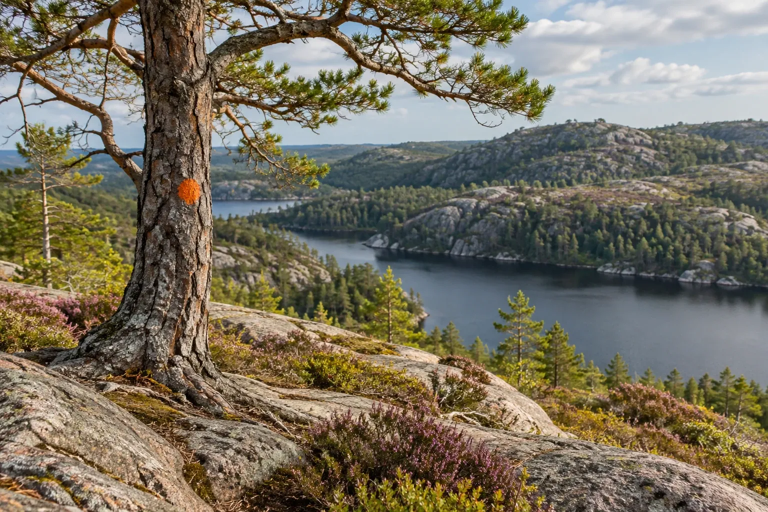
Bohusleden starts as a day walk you can reach by tram from Gothenburg, then runs north through ever wilder country near the Norwegian border to Strömstad. This guide explains how the trail changes along the way, where transport stops, and where you may sleep.
When you need this
You’re in Gothenburg and want a marked walk with a tram or train at each end. Or you’re planning several days through Bohuslän without a car and need to know which stage ends have no bus at all. You might also have read “370 km from Lindome” somewhere and want to know which figure is current.
How the trail is built
Bohusleden (“the Bohus trail”) runs inland of the Bohuslän coast, through forest, lakes and bare rock hills. Its official site, part of West Sweden Trails, gives 27 stages and about 350 km. The trail starts at Älvsåker on the Halland border, south of Gothenburg, where it meets Hallandsleden, and it ends in Strömstad’s town centre. The published stage lengths add up to about 354 km. Stages run from 6 km (stage 16) to 26 km (stage 1), and the official walking times total roughly 120 to 138 hours.
Don’t trust older figures. Older texts say the trail starts in Lindome and is 37 mil (370 km) long. Even the closing paragraph of the official stage 27 page still says so. The official front page now gives Älvsåker and about 350 km.
No single owner runs the trail. Västkuststiftelsen, a foundation, coordinates the development of selected long trails in Västra Götaland and runs the website. The eleven municipalities on the stage pages look after their own stretches. Stage 21, for example, is Tanum’s responsibility.
The trail gets wilder as it heads north. Section lengths below are our sums of the official stage lengths.
| Section | Stages | Length | Character |
|---|---|---|---|
| Gothenburg fringe | 1–6 | about 82 km | Gunnebo, Delsjön, Partille, Jonsered, Vättlefjäll, Bohus Fortress; trams and trains |
| Svartedalen and the lake plateau | 7–10 | about 49 km | One of West Sweden’s largest continuous conifer forests; very rare buses |
| Uddevalla and Munkedal | 11–18 | about 103 km | Bredfjället, Bjursjön, the raft over Munkedalsälven, the salmon river Örekilsälven |
| Kynnefjäll and the border | 19–23 | about 62 km | The wilderness core, the stage 21 gap, Älgafallet waterfall |
| Strömstad hills | 24–27 | about 58 km | Bare rock, a wind farm, Björnerödspiggen, rock carvings, Strömstad |
Stages 2–6 also form the Swedish Tourist Association’s Signaturled Göteborg. At the other end, stage 26 climbs Björnerödspiggen, Bohuslän’s highest hill at 222 m. Stages 17–18 follow a newer route, and stage 20 now ends at Flötemarksön, formerly called Holmen.
Getting there by train, tram and bus
Access is excellent in the south and poor in the north. Stations and stops named on the official stage pages include:
- Anneberg commuter-train station — rail access to the start at Älvsåker
- Welandersgatan tram and bus stop — near Skatås, between stages 2 and 3
- Jonsered railway station — right beside the trail at the start of stage 5
- Munkedal railway station — a walk through town, described on the stage pages, to stages 15 and 16
- Strömstad — buses and trains at the end of stage 27
The north is a different story. Hasteröd (stages 10–11), Bjursjön and Metsjö (stage 14), and Vaktarekullen and Flötemarksön (stage 20) have no public transport at all. On stage 19 the official site warns that buses, where they exist, are very sparse at weekends and in school holidays.
Tickets change zone as you walk. Västtrafik covers all of Västra Götaland plus Kungsbacka, in three zones. The trail starts in zone B (Kungsbacka), crosses zone A (Mölndal, Gothenburg, Partille), returns to zone B (Kungälv, Stenungsund, Lilla Edet) and ends in zone C, from Uddevalla northwards. Tapping a bank card on the reader only buys a zone A ticket. On buses outside Gothenburg, Mölndal and Partille you can buy from the driver by bank card, or use the Västtrafik To Go app. The Gothenburg public transport guide covers tickets in depth.
Sleeping: shelters, tents and reserves
The trail has open shelters (vindskydd) along the way. The official stage pages mention no fee or booking for them, but there’s no official total count, so don’t plan on one every night. Two huts are worth knowing:
- Vaktarekullen, at the end of stage 19, is an open overnight hut with a fire place and toilet. The official site suggests stage 20 as a rest day here, walking Kynnefjäll’s other trails with a light day pack.
- Modalen, near stage 15, must be booked through Friluftsfrämjandet, an outdoor association.
Under allemansrätten (the right of public access) you may pitch a tent away from homes and farmland. Naturvårdsverket, the Swedish EPA, calls one or two nights a good rule of thumb; that’s guidance, not a number in a statute. Large groups must ask the landowner. See the wild camping guide for the full rules.
The nature reserves are where this gets strict. Their regulations are law, and on Bohusleden several restrict tents:
| Reserve | Stages | Tents | Fire | Dogs |
|---|---|---|---|---|
| Delsjöområdet | 2–3 | Not allowed | Designated places only | — |
| Vättlefjäll | 6 | — | Designated places only | On a lead all year |
| Svartedalen, wilderness areas 1–2 | 8–9 | Not allowed | Designated places only | — |
| Svartedalen, area 3 | 8–9 | — | Designated places only | On a lead all year |
| Kynnefjäll | 18–20 | Designated places only | Designated places only | — |
A dash means the county board’s visitor summary lists no such rule. The stage pages name tent sites at Romesjön on stage 7 and at Bottenstugan at the end of stage 8. Each stage page links to the reserves it crosses, so read those rules before you pick the night’s stop. Our guide to nature reserves explains why they override allemansrätten.
North of Flötemarksön, a paid wilderness camp and the Nornäs shelter at the end of stage 22 are about 22 km apart. Carry a tent or plan a long day.
Water, fire and food
Water: the map planner on the official site has a Dricksvatten (drinking water) filter, but the site advises carrying your own water when in doubt. Stage 14 has hand pumps at Ålslån and Hällerstugan. Spring water should be boiled; the site says so for the spring at Vaktarekullen.
Fire: each municipality decides fire bans after consulting its fire service, and at very high risk the county board can ban fires county-wide. Check the Krisinformation.se map for every municipality on your route. Inside the reserves above, fires are allowed only at designated places anyway. Never light a fire on bare rock, because it cracks. Firewood isn’t guaranteed: reserves usually have no wood stores, and shelters that get wood aren’t always topped up. Björnerödspiggen often has wood; carry a stove regardless. You can be punished for causing a fire through carelessness, ban or no ban. See fire bans in Sweden.
Food: from stage 19 the official site warns that you can’t restock near the trail and must carry your pack for several days.
Fishing: most lakes and rivers need a fishing licence or the owner’s consent. Örekilsälven on stage 16 has Atlantic salmon from May to September, licence required.
Marking and the stage 21 gap
Bohusleden is marked with orange paint on trees and posts, which works in either direction. Each stage starts with an information board showing distances, a symbol map and allemansrätten facts. The official site still says marking standards vary and recommends always carrying a map or GPX file. Every stage page has a GPX download, and the map planner exports several stages as one file.
Stage 21 is the exception that matters. Between Flötemarksön and Porsås the trail isn’t continuous. Marking runs only from Flötemarksön to the bridge at Holmen, about 4 km, and again from road 164 to Porsås. In between you navigate with map and compass on paths and small roads. Road 164 is a clear boundary to the north; walking south, Stora Kornsjön is on your left. The official site recommends this stage only to people walking the whole trail. Tanum municipality says it is working to reconnect it.
Two other trails share the route. Kuststigen runs with Bohusleden on stages 24–26 and leaves northwards from Björnerödspiggen. At Älgafallet, a 46 m waterfall on stage 23, a footbridge takes you into Norway and onto the Norwegian Kyststien.
The demanding parts
Seventeen stages are graded blue and ten red, which the regional tourist board describes as difficult. Red stages are 5, 8, 9, 14, 15, 21 and 23 to 26. The specific hazards:
| Stage | What to expect |
|---|---|
| 9 | Ropes on steep passages; no mobile coverage on large parts — tell someone your route |
| 14 | Short steep sections with ropes |
| 15 | A rope-pulled raft over Munkedalsälven: pull it over, cross, and leave the ropes untied; in an accident call 112 |
| 20 | A burnt, overgrown area where the trail is harder to see |
| 21 | Unmarked section; map and compass needed |
The southern stages near Gothenburg are the gentlest. If you get lost or hurt anywhere, call 112. It’s free and works without a SIM card.
Dogs, ticks and the hunt
| Issue | Rule or risk | Status |
|---|---|---|
| Dogs, 1 March–20 August | Must be kept from running loose where there is wildlife; in practice a lead | Law |
| Dogs in some reserves | Lead all year in Vättlefjäll and Svartedalen’s area 3 | Law (reserve rules) |
| Vättlefjäll, 1 May–10 June | No access to the Surtesjön area, to protect breeding black-throated divers | Law (reserve rules) |
| Ticks and TBE | Gothenburg, Kungälv, Stenungsund, Lilla Edet, Uddevalla, Munkedal, Tanum and Strömstad are risk area 1; Kungsbacka and Mölndal risk area 2 | Official guidance |
| Moose hunt | 8 October–31 January in Västra Götaland’s moose areas | Law (hunting period) |
With a dog, keep well clear of grazing cattle and horses. The hunt doesn’t close the trail, but wear visible colours in autumn; see hiking during hunting season. Check your TBE vaccination before a long walk with the TBE vaccine guide.
Practical information
| Item | Detail |
|---|---|
| Length | About 350 km in 27 stages; stages 6–26 km |
| Start and end | Älvsåker (Kungsbacka) to Strömstad centre |
| Marking | Orange paint on trees and posts; information board at each stage start |
| Walking the trail | Free, no permit |
| GPX and map planner | Free download from the official site (checked 2026-10-15) |
| Shelters | No fee or booking mentioned on the official stage pages (checked 2026-10-15) |
| Modalen hut | Book through Friluftsfrämjandet; price on its site (checked 2026-10-15) |
| Tickets | Västtrafik zones A, B and C; fares on Västtrafik’s site (checked 2026-10-15) |
| Fishing | Licence needed in most lakes and rivers |
| Fire bans | Per municipality; Krisinformation.se map |
| Emergency | 112 |
FAQ
How long is Bohusleden?
About 350 km, according to the official trail site, split into 27 stages from Älvsåker on the Halland border to Strömstad near Norway. The published stage lengths add up to about 354 km. Stages run from 6 to 26 km, and the official walking times total roughly 120 to 138 hours. Older texts say 37 mil from Lindome; that start is out of date.
Can I reach Bohusleden by public transport from Gothenburg?
Yes, for the southern stages. Anneberg commuter-train station serves the start at Älvsåker, Welandersgatan tram stop is near Skatås, and Jonsered railway station sits beside the trail. Further north access gets harder: several stage ends, including Bjursjön, Metsjö and Vaktarekullen, have no public transport at all. Munkedal and Strömstad have railway stations.
Can I camp or sleep in shelters on Bohusleden?
Yes, with care. The trail has open shelters along the way, and allemansrätten lets you pitch a tent for a night or two away from homes. But some nature reserves ban tents: Delsjöområdet near Gothenburg, Svartedalen’s wilderness areas and, except at designated sites, Kynnefjäll. Check each reserve linked from the stage page before choosing where to sleep.
How difficult is Bohusleden?
Seventeen stages are graded blue and ten red, which the regional tourist board describes as difficult. Red stages include 9, with ropes on steep passages, and 14, 21 and 23 to 26 in the hilly north. The southern stages near Gothenburg are the easiest. In the northern wilderness you carry several days’ food, because you cannot restock near the trail.
Is Bohusleden well marked?
Mostly. Orange paint on trees and posts marks the trail in both directions, and each stage starts with an information board. The exception is stage 21, where the section between the bridge at Holmen and road 164 is not marked at all and you navigate with map and compass. The official site recommends carrying a map or GPX file everywhere.
Can I bring my dog on Bohusleden?
Yes. From 1 March to 20 August Swedish law requires dogs to be kept from running loose where there is wildlife, which in practice means a lead. Some reserves require a lead all year, including Vättlefjäll on stage 6. Keep well clear of grazing cattle and horses, and remember the moose hunt starts on 8 October.
Related guides
- Bohuslän and the west coast — the coast, islands and ferries the trail runs inland of.
- Gothenburg public transport — Västtrafik zones and tickets for the southern trailheads.
- Wind shelters in Sweden — how vindskydd work and the etiquette for sharing them.
- Nature reserves and allemansrätten — why Svartedalen’s and Kynnefjäll’s rules beat the right of access.
- Sörmlandsleden — the long-distance trail from Stockholm, if you want another.
Facts verified 2026-10-15. Sources: Västkuststiftelsen / West Sweden Trails, Turistrådet Västsverige, Länsstyrelsen Västra Götaland, Naturvårdsverket, Folkhälsomyndigheten, Krisinformation.se, Västtrafik, SOS Alarm and Sveriges riksdag (Lag 2007:1150) — full register in this topic’s source file. Found something outdated? Tell us and we’ll fix it.