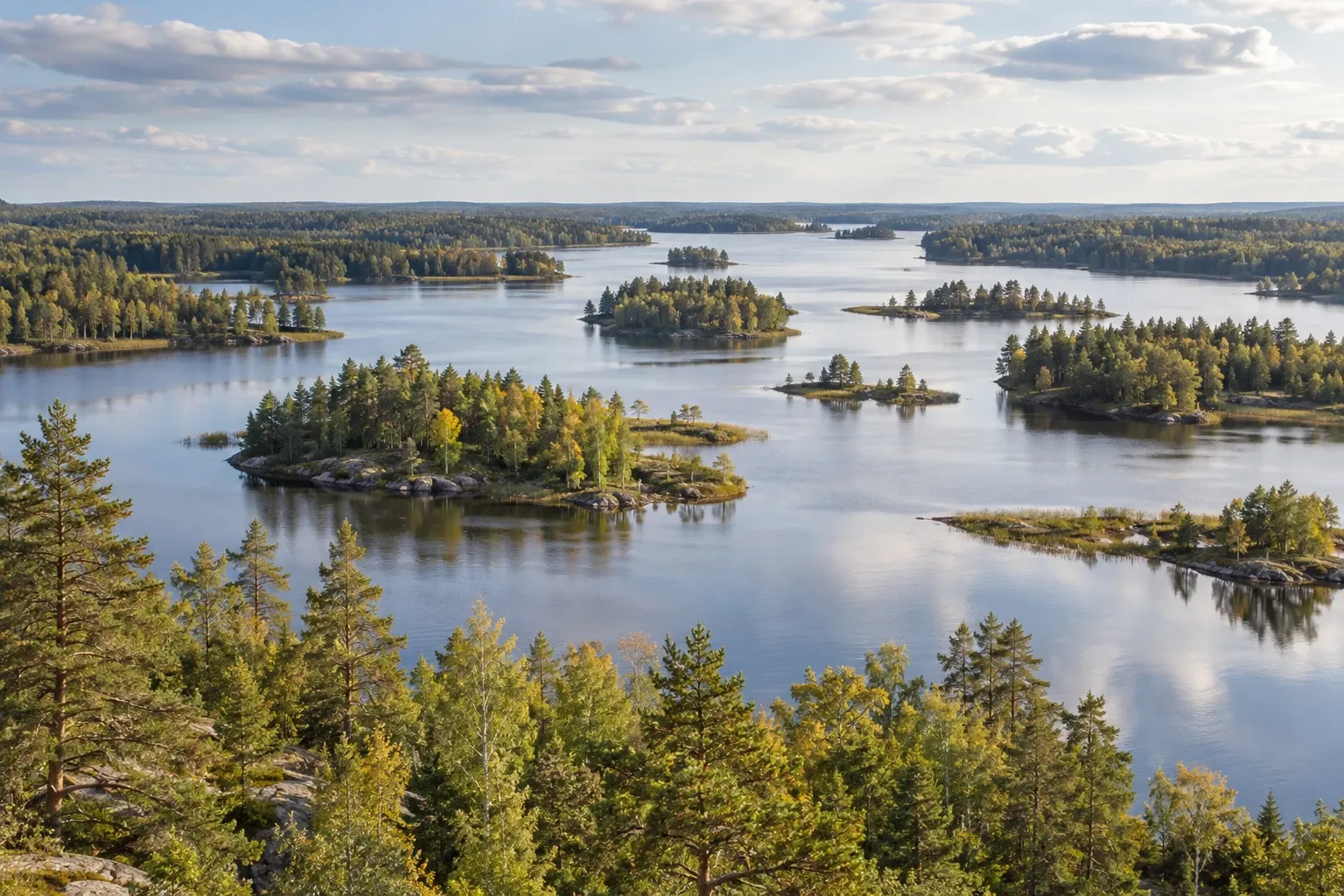
Färnebofjärden is Sweden’s river park: a wide, island-studded stretch of the Dalälven where northern and southern nature meet, between Uppsala and Gävle. It is gentle walking and superb paddling, with binding rules that are stricter than the right of public access.
When you need this
You’re in Uppsala, Gävle or Stockholm and want a day of birdwatching, canoeing or easy forest walks. Or you’re wondering whether the dog, the bike, the fishing rod, the motorboat or the drone can come, and where you’re allowed to sleep. Our guide to Swedish national parks explains the system; this page covers Färnebofjärden itself — how to get in, what the regulations actually say, and what is open when.
The park at a glance
Färnebofjärden was formed in 1998 and covers 10,464 hectares, about 105 km², where four counties meet: Gävleborg, Uppsala, Västmanland and Dalarna. It lies in Sala, Heby, Avesta and Sandviken municipalities, and the county board of Gävleborg manages it. King Carl XVI Gustaf opened it in 1998; a stone on the short Kungsslingan trail marks the spot.
The park protects a stretch of the Lower Dalälven (Nedre Dalälven) in an almost untouched state. A fjärd is a wide, lake-like section of water, and this one holds more than 200 islands and skerries, many of them formed by a long esker — a ridge of glacial gravel — running through the park. Periodic floods shape everything: shore marshes, river meadows, swamp forest and old-growth forest.
Why naturalists come. The biological border of Norrland, Limes Norrlandicus, runs straight through the park, so northern bog and conifer forest sits beside southern oak and linden. The national-parks site counts 205 bird species, just over 100 of them breeding regularly, including several red-listed woodpeckers and owls.
Getting there
The park lies between Uppsala, Gävle, Avesta and Västerås. Gysinge, on its northern edge, is where most visits start: naturum (the visitor centre) is there, and the bus stops there.
| Mode | How it works |
|---|---|
| Bus | X-trafik Gävleborg runs buses to Gysinge. Get off at Brukshandeln; naturum is a 500 m walk, and trails lead into the park. The park page gives no line number, so plan in X-trafik’s journey planner |
| Car from Gävle | Road 56 south, then turn off for Gysinge; signs point to naturum and the main entrance |
| Car from Uppsala | Road 272 towards Gysinge, then the turn-off for the park |
| Bike | Allowed on the roads to every entrance — but not on the park’s trails (see the rules) |
| Boat or canoe | Skekarsbo has a jetty; Balforsen can be reached by canoe, but there are rapids on the way |
The four entrances. Each has parking, a dry toilet, a shelter and a fire place.
| Entrance | Where | What’s there |
|---|---|---|
| Main entrance (Nord and Syd, 600 m apart) | On Mattön, about 2.5 km southeast of Gysinge: cross the bridges from Gysinge, keep left, car park on the left | Shelters, fire places, picnic tables, a wooden grandstand, the accessible trail and the short loops |
| Skekarsbo | About 8 km northwest of Tärnsjö | Jetty, several shelters, the 20 m observation tower |
| Balforsen | About 18 km southeast of Horndal | Viewing platform by the river; the rapids trail |
| Öberget | About 12 km southwest of Tärnsjö | A simple service point in the conifer forest; start of the longest trail |
For Öberget, drive via Hallarsbo and follow the signs. GPS sometimes suggests a road west of Lillsjön that is usually impassable.
The rules
The park’s binding regulations are NFS 2014:16, amended by NFS 2014:26 in force since 1 January 2015. They replaced the original 1998 regulations, and Naturvårdsverket lists no later change. Inside a national park the right of public access (allemansrätten) is limited, so “a night or two anywhere” does not apply here. These are the rules that matter to visitors, read from the regulation itself:
| Activity | The rule |
|---|---|
| Tent, hammock, bivouac | Only at designated places: 12 of the 28 shelters and three other marked sites |
| Sleeping in a shelter or open cabin | Allowed at all 28 shelters and the four open cabins (two nights max in the cabins) |
| Fire | Only at designated fire places; a camping stove and a grill are allowed |
| Wood | No breaking twigs and no damaging living or dead trees and bushes |
| Dogs and other pets | Leashed at all times, all year |
| Cycling and riding | Only on car roads and car parks |
| Motor vehicles | Only on roads and car parks, including on ice |
| Signed bird areas | No entry 1 January–31 July; around islands, the ban covers 100 m of water |
| Motorboats | 7 knots max, except a marked 50 m lane at 12 or 20 knots; no jet skis, no water-skiing or wakeboarding |
| Five closed waters | No motorboats and no fishing on Tiån, Tisjön, Östasjön, Kölforsån or Lillån |
| Drones | No aircraft may take off or land, and nothing may fly below 300 m |
| Plants, fungi, small animals | No picking plants, mosses, lichens or wood-living fungi, and no collecting insects, snails, frogs or reptiles |
| Berries and mushrooms | Allowed for your own use, outside the closed areas |
The cycling ban is the one that catches people out: the national-parks site’s own rule list leaves it out, but the regulation and the county board are clear. The regulation says luftfartyg (aircraft) without naming drones; our reading, consistent with our drone rules guide, is that a drone is covered — ask the county board before flying.
Hunting happens here. Hunting for moose, roe deer, beaver and wild boar is allowed outside 1 January–15 August, and hunting dogs may run loose during it. If you walk in autumn, read hiking during hunting season.
Fire bans override the fire places. The park spans four municipalities in four counties, so check the ban for the one you are standing in — see fire bans in Sweden. A camping stove usually stays legal under an ordinary ban.
Walks and what to see
The trails are flat but wet: boardwalks (spänger), stones and roots get slippery, and floods put parts of them under water.
| Trail | Length | Start | Notes |
|---|---|---|---|
| Accessible nature trail | 500 m | Main entrance | Widened path upstream to a jetty with a river view |
| Kungsslingan | 1 km | Main entrance Nord | Along the rapids, past the king’s stone |
| Skekarsboslingan | 3 km | Skekarsbo | Past the 20 m tower to the Brattnäset shelter (tent allowed) |
| Bändanslingan | 3.5 km | Main entrance | To the southern tip of Mattön; first 400 m hard-surfaced |
| Härsingen–Stadarna | 4 km | Härsingen or Stadarna (west) | Along three rapids, four shelters, tent allowed at Sågen |
| Gysinge–Tegelbruket | 5 km | Gysinge or Tegelbruket | Stage 13 of the Gästrikeleden trail; impassable at high water |
| Mattön runt | 7.5 km | Main entrance Nord or Gysinge | Half of it in Gysinge nature reserve |
| Stora Öbergsrundan | 17 km | Öberget | Old forest and Lindebergsmossen bog, the wildest part; fallen trees may block the way |
Skekarsbo tower. The top floor of the 20 m tower stands 97 m above sea level and looks over almost the whole park, with a chance of white-tailed eagles and ospreys. It is about 300 m from the Skekarsbo car park.
Sandön. An island in the middle of the fjärd with the park’s best sand beach, a shelter, fire places and tenting allowed. You reach it only by boat or canoe.
The Tinäs area in the southwest is known for its birdlife, but expect longer walks into the big conifer forests and wetlands. Our birdwatching guide puts Färnebofjärden in national context.
naturum Färnebofjärden sits in an 1814 stable at Gysinge bruk beside the rapids. Listen to woodpeckers, visit a beaver lodge in the exhibition, and help feed the 14 young trout in the floor pool at 13.00 on open days — free. Owl evenings, bird mornings and holiday activities run through the year. Opening hours are in the table below.
On the water: paddling and fishing
The national-parks site says the park is perhaps best experienced from the water. Bring your own boat or canoe, or rent from one of the park’s partner businesses (the park keeps the list). Launch points include Gysinge, Skekarsbo, Linsjön on the Östa peninsula, Stadarna in the Tyttbo area, the beach at Edsviken south of Österfärnebo and Hemön on the Ista peninsula. White-water paddling is possible at Gysinge, Sevedskvarn and Tyttbo. For the basics, see canoeing in Sweden.
Two things to watch: the 7-knot limit if you have an engine, and the floating signs that mark closed bird islands from 1 January to 31 July. The ban covers the water 100 m around them, not just the land.
Fishing needs a licence (fiskekort), and which one depends on where you stand:
| Area | Water | Fish |
|---|---|---|
| Gysingeforsarna | The rapids at Gysinge and the Sevedskvarn entrance area | Trout, grayling |
| Färnebofjärden | The central fjärds | Pikeperch, pike |
| Tyttbo forsfiske | The westernmost rapids | Trout, grayling |
Fishing is banned in Tiån, Tisjön, Östasjön, Kölforsån and Lillån, and public fishing is banned between Sjöforsen and Långlådingen. For general licence rules see fishing rules in Sweden; for the fjärds, pike fishing in Sweden.
Where to sleep
| Option | What it is | Booking |
|---|---|---|
| 28 open shelters (vindskydd) | Sleep in any of them; tent at 12 of them | Not bookable; you may have to share |
| 3 extra tent sites | Marked places, including Sandön | Not bookable |
| 4 open cabins (raststugor) | Very simple; two nights max. Alderbäcksrör is closed 1 October–31 December; Tinäsbodarna and Bengts stuga are easiest from the water | Not bookable, free |
| Torröstugan | On the island of Torrön in the Tyttbo area, a short row across the river; six beds, rowing boat with life jackets included | Rented through the Swedish Tourist Association (STF) |
| Stad-Arvids stuga | On the mainland in the Tyttbo area; six beds plus two in a small annexe | Rented through STF |
| Your vehicle | Up to two nights in a car, motorhome or caravan at the entrance car parks | No booking |
Sleeping anywhere else in the park breaks the regulations. Outside the park, ordinary wild camping rules apply, and our motorhome guide covers stops elsewhere.
Accessible visits
Färnebofjärden is well set up for accessible visits:
- Every entrance has hard-surfaced areas that work with a wheelchair, rollator or pushchair, plus adapted outhouses and shelters; so does the beach at Hemön.
- Accessible picnic tables stand at the main entrance, Skekarsbo and Balforsen.
- The accessible nature trail (500 m) has two adapted shelters, tables with wheelchair space and information boards at adapted height. The first 400 m of Bändanslingan is also hard-surfaced.
- naturum has an adapted toilet and a lift to the upper floor.
- Skekarsbo tower is not wheelchair accessible; the path to it is smooth but somewhat steep, and the stairs have handrails on both sides.
- Powered wheelchairs are explicitly allowed by the regulation, outside the closed bird areas.
More in our accessible Sweden guide.
Season by season
- 1 January–31 July: the signed bird areas are closed, for nesting ospreys, terns and spawning fish.
- Spring and early summer: floods can put trails under water. Early summer also brings floodwater mosquitoes — the Nedre Dalälven floodplains are Sweden’s best-documented mosquito area, and Naturvårdsverket has renewed the permit for larvicide control there for 2026–2028. Pack repellent and long sleeves; see mosquitoes in Sweden.
- From 16 August: hunting for moose, roe deer, beaver and wild boar may take place.
- Autumn and winter: Alderbäcksrör cabin closes 1 October; naturum opens on fewer days (see below).
Current conditions. Two areas in the central fjärd were recently burned for conservation, and the county board advises against visiting them because damaged trees can fall. The county board also reports that a storm it names Johannes left large amounts of windthrown forest: trails at Gysinge, Tyttbo and Skekarsbo are cleared, but some paths elsewhere cannot be walked. Ask naturum before a long walk.
Practical information
| Item | Detail (checked 2026-10-15) |
|---|---|
| Entry | No entry fee mentioned by the county board or the national-parks site |
| Parking | Free at every entrance; up to two nights in a car, motorhome or caravan |
| Shelters and open cabins | Free, not bookable |
| Rented cabins | Torröstugan and Stad-Arvids stuga, through STF; price at booking |
| Fishing licence | From the fishing-management area you fish; price at purchase |
| naturum 2026 hours | May and 1–18 June Wed–Sun 11–16; 20 June–31 August daily 11–17; September Thu–Sun 11–16; October Thu–Sun 11–15; autumn half-term 26 October–1 November 11–15; Christmas market 5 December 11–15. No other hours published after October |
| Defibrillator | In naturum, during opening hours |
| Food | Restaurant, café and small shop in Gysinge; more in Österfärnebo, Tärnsjö and Hedesunda |
| Bins | Gysinge, main entrance, Skekarsbo, Balforsen, Strångnäs on Hemön |
| Contact | [email protected] · 010-225 15 16 |
FAQ
Can you camp in Färnebofjärden National Park?
Yes, but only at designated places. You may sleep in any of the 28 open shelters, and tent, hang a hammock or sleep on the ground at 12 of them and at three other marked places. There are also four free open cabins, maximum two nights. Sleeping anywhere else in the park breaks its regulations. Car parks allow up to two nights in a vehicle.
How do you get to Färnebofjärden without a car?
Take an X-trafik Gävleborg bus to Gysinge and get off at Brukshandeln. From there it is a 500 m walk to naturum, the park’s visitor centre, and trails lead into the park, with the main entrance about 2.5 km southeast on Mattön. The park page names no line number, so plan the trip in X-trafik’s journey planner.
Can I bring my dog to Färnebofjärden?
Yes, but on a leash all year. The park’s regulations forbid bringing a dog or any other pet that is not leashed, so the national 1 March–20 August period does not apply here. The only exception is hunting dogs during the moose, roe deer, beaver and wild boar hunting the regulations allow. Keep dogs away from nests and dens.
Can you cycle in Färnebofjärden National Park?
Only on car roads and in car parks. The regulations ban cycling and riding everywhere else in the park, so the walking trails, boardwalks and forest paths are off limits to bikes. You can still cycle the roads to the four entrances; the national-parks site lists bike as one way to reach each of them. Lock up at the car park and walk on.
Where can you fish in Färnebofjärden?
The rapids at Gysinge, Sevedskvarn and Tyttbo hold trout and grayling, and the fjärds hold pikeperch and pike. You need a licence from the right one of three fishing-management areas: Gysingeforsarna, Färnebofjärden or Tyttbo forsfiske. Fishing is banned in Tiån, Tisjön, Östasjön, Kölforsån and Lillån, and public fishing is banned between Sjöforsen and Långlådingen.
Which areas are closed in Färnebofjärden, and when?
From 1 January to 31 July, signed bird-protection areas are closed to everyone, and around islands the ban covers the water within 100 m. They protect nesting ospreys, terns and spawning fish. Buoys and floating signs mark them. Separately, two recently burned areas are not closed, but the county board advises against visiting because damaged trees can fall.
Related guides
- Swedish national parks — how the park system works and how the other parks compare
- Canoeing in Sweden — the skills and kit for paddling the fjärd and its rapids
- Birdwatching in Sweden — where else to go for the birds Färnebofjärden is known for
- Hiking during hunting season — what to wear and expect from mid-August
- Leash law in Sweden — the national dog rules this park tightens
Facts verified 2026-10-15. Sources: Naturvårdsverket (park regulations NFS 2014:16 and the national-parks site), Länsstyrelsen Gävleborg, X-trafik Gävleborg — full register in this topic’s source file. Found something outdated? Tell us and we’ll fix it.