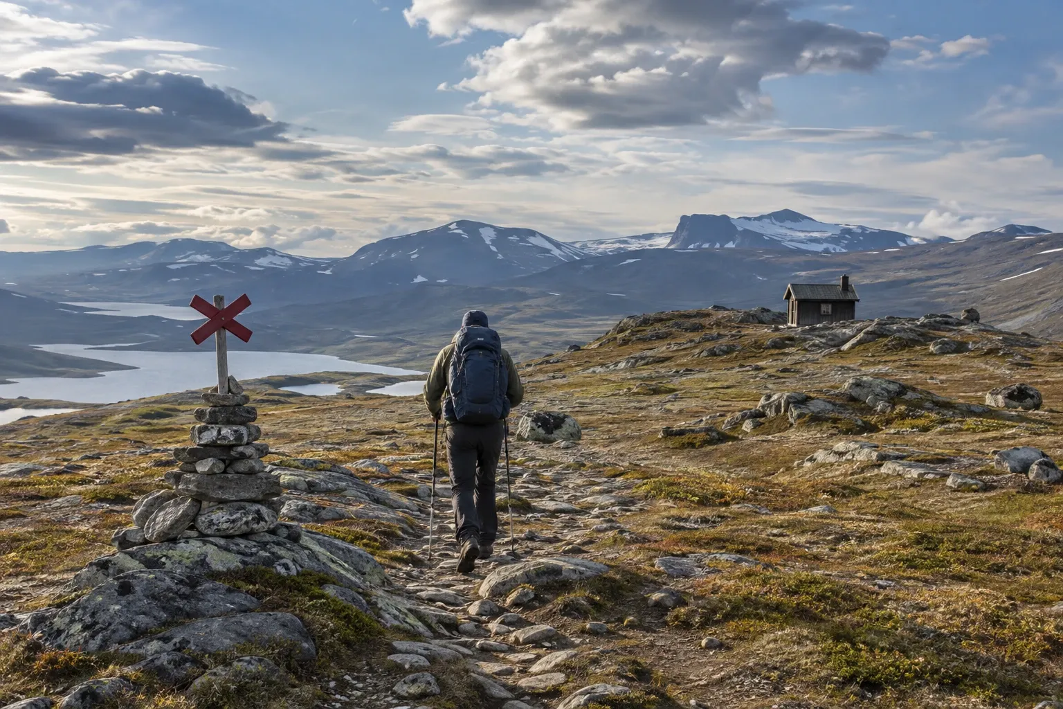
The Swedish mountains aren’t the Alps, and that’s the trap. The danger is quieter: weather that turns in an afternoon, a river swollen by snowmelt, a line of red crosses leading into a bog, and no phone signal. Sweden has a public safety system built for exactly this. Here’s how it works.
When you need this
You’re planning a first hike or ski tour in the fjällen, the mountain range running more than 1,000 km along the Norwegian border. Maybe you’re choosing between a hut-to-hut trail and a wilderness park like Sarek. Maybe you’re working out what to tell family at home, or whether you need a satellite device. Or something has gone wrong and you need to know who to call.
The system behind the trails
Few visitors realize how much public infrastructure sits behind a Swedish mountain hike:
- About 5,500 km of state-marked trails cross the mountains of Dalarna, Jämtland, Västerbotten and Norrbotten. Naturvårdsverket, the Swedish Environmental Protection Agency, is responsible; the county boards, and Laponiatjuottjudus in the Laponia world heritage area, maintain the trails, shelters, signs and bridges.
- Most overnight huts in roadless country are run by the Swedish Tourist Association (STF).
- Most huts and many rest shelters have a help phone (hjälptelefon) connected to an alarm centre.
- Mountain rescue (fjällräddning) is a police job, done with roughly 400 trained volunteers in about 30 local groups, and alarmed through 112.
The advice on this page comes mainly from Fjällsäkerhetsrådet, the Mountain Safety Council, which works under Naturvårdsverket. Naturvårdsverket also runs lavinprognoser.se, the national avalanche forecast.
Before you go
Pick a route that fits. Fjällsäkerhetsrådet suggests about 5 km a day with children and 10–15 km for adults new to the mountains. First trip? Stay on marked trails.
Carry the mountain map (fjällkarta) and a compass, even on marked trails. The map shows trail types, huts, rest shelters and a telephone symbol wherever there’s a help phone. GPS is fine, but cold drains batteries fast.
Check the weather — twice. Weather in the fjäll turns quickly, and rain and hard wind come even in summer. Check SMHI’s forecast and warnings before leaving and again on the way. SMHI issues specific warnings for wind and snowfall in the mountains and for strong wind chill; respect them. See emergency alerts and SMHI warnings.
Leave a travel plan (färdmeddelande). This is the single most important habit. Tell a friend or relative:
| Tell them | Why |
|---|---|
| Your route and planned stops | Searchers know where to look |
| Start time and expected return | They know when to worry |
| Who is in the group, and key gear | Rescuers know what you can survive |
| That they should raise the alarm if you don’t report back | Someone actually acts |
Then sign the guestbook in every hut and shelter you pass. Nobody follows these up unless you’re reported missing, but then searchers read them.
One subtle point: don’t promise “I’ll call.” If your phone finds no signal, your silence causes needless worry — or a needless search.
Reading the trail markings
This is where visitors most often go wrong.
| Marking | Means |
|---|---|
| Small cairns (rösen), sometimes with a red top | Summer trail above the treeline |
| Painted rings or dots on trees | Summer trail in birch forest |
| Red crosses on poles (ledkryss), about 40 m apart | Winter route |
| Red crosses where the two routes coincide | Summer and winter routes share the line |
Winter routes run across frozen lakes and wetland. Follow the crosses in July and you can walk into a bog — or straight toward open water. Where the routes share a line, the crosses mark both; everywhere else, look for the cairns.
Rest shelters and help phones
Roughly halfway between overnight huts on the state trails you’ll find a rest shelter (rastskydd). Three rules:
- They are not accommodation. Use them for breaks and bad-weather shelter; sleep in one only in an emergency. There’s always room for someone who needs a roof.
- Never run a camping stove inside. Any stove, any fuel: carbon monoxide can kill in a small closed room.
- The wood stove is for emergencies. Open the ventilation first, burn for no more than 2–3 hours, then let it rest as long. Close the door when you leave.
Many shelters and hut safety rooms hold an emergency box (nödlåda) with food, first aid and repair kit — for real emergencies, with instructions for reporting what you used.
Help phones are for more than accidents. Fjällsäkerhetsrådet says they’re for anyone who feels unsafe or unsure. Running a day late? Call to say so — it can stop a search before it starts. They stay accessible outside the hut season, but reach only an alarm centre, not other numbers.
Your own phone is less reliable. Telia usually reaches farthest, but in northern Lappland coverage is very limited and often absent. Some phones offer satellite emergency messaging, and a satellite phone reaches SOS Alarm on +46 63 107 112. Details in mobile coverage in the wilderness.
Rivers, snowmelt and avalanches
On marked trails, bridges cover most rivers that would otherwise need a risky wade. Off-trail, wading is one of the biggest risks in the fjäll:
- Choose the widest, shallowest point, where the current is weakest.
- Don’t wade if the water is fast and above knee height.
- Wear shoes or sandals — never barefoot.
- Unbuckle hip belt and chest strap so you can shed the pack if you fall.
- Use a pole, face angled into the current, cross one at a time.
In late spring, snowmelt raises rivers fast, especially in deep valleys. Rain on melting snow can also trigger slushflows — fast mixtures of water and snow — on gentle slopes of about 5–30°. Be careful near streams and hollows in May and June.
In winter, check lavinprognoser.se. It publishes daily avalanche assessments for six areas: Abisko/Riksgränsfjällen, Kebnekaisefjällen, Västra Vindelfjällen, Södra Lapplandsfjällen, Södra Jämtlandsfjällen and Västra Härjedalsfjällen, in English too. Forecasts start in mid-December; outside those six areas you judge the risk yourself. The basics: stay on trails, ski wide open valleys, avoid slopes steeper than 25°, and keep off steep snow after heavy snow, hard wind or a sharp thaw — most avalanches come the day after a storm.
When to call for rescue — and who pays
Call 112 and ask for fjällräddning when life or health is at risk, or use the nearest help phone. Be ready to answer three things: what happened, where, and how many are hurt. Then expect to wait — weather and priorities decide how fast help arrives. Full calling advice is in Sweden’s emergency numbers.
Fjällsäkerhetsrådet is blunt about what isn’t a rescue: illness, minor injuries, poor gear or a weather delay are yours to solve. That can mean waiting an extra day, or hiring and paying for transport; hut wardens can help arrange it.
On cost, here’s exactly what we verified:
| Situation | Who pays |
|---|---|
| Police-led rescue, life or health at risk | We found no rule billing the rescued person; the Civil Protection Act’s cost chapter covers payments between public bodies and volunteers |
| Deciding whether to rescue you | Police say need is never weighed against your private cost |
| Helicopter pick-up when you’re simply tired | You — police can put you in touch with an operator |
| Ambulance or air ambulance after rescue | Healthcare, billed by the region |
That last row is why travel insurance still matters in the mountains.
Sarek and the trail-less north
Sarek National Park has no marked trails and no huts in its interior (only Kungsleden crosses its southern part), and crossing it means many difficult wades. You need confident map-and-compass navigation, multi-day tent experience and all your food. Mobile coverage is weak. The park is managed by Laponiatjuottjudus, and its own regulations apply.
Beginners can still see it: STF’s huts and stations on Kungsleden just outside, such as Aktse, work as bases for day trips.
Reindeer graze across the mountains, Sarek included. Allemansrätten applies here, but it must not cause real harm to the Sami villages’ (samebyar) herding. Give herds room, especially at spring calving, and keep dogs on a lead when reindeer are near — the law requires it (see leash rules, including the national parks where dogs are restricted). See wild camping for tent rules.
Practical information
| Item | Detail |
|---|---|
| Emergency number | 112 — ask for fjällräddning |
| Satellite phone | +46 63 107 112 (your provider’s rate) |
| No signal | Hut or shelter help phone (telephone symbol on the map) |
| Rescue run by | Police, with volunteer mountain rescuers |
| Rescue cost when in danger | No rule billing the rescued found |
| Non-emergency transport | At your own cost |
| Avalanche forecast | lavinprognoser.se, six areas, daily from mid-December |
| Weather warnings | SMHI, incl. mountain wind, snowfall and wind chill |
| Winter route marking | Red crosses on poles, about 40 m apart |
| Summer trail marking | Cairns; painted rings or dots in birch forest |
| Rest shelters | Breaks and emergency shelter only; no stoves inside |
| Hut nights | STF — prices and staffed seasons vary, check STF |
FAQ
Is mountain rescue free in Sweden?
When life or health is at risk, police lead the rescue and we found no rule billing the rescued person: the Civil Protection Act’s cost chapter covers payments between public bodies, and police say need is never weighed against cost. Being tired or lightly hurt is different — you arrange and pay for your own transport. Ambulance care afterward is billed as healthcare.
What number do I call for mountain rescue in Sweden?
Call 112 and ask for fjällräddning, mountain rescue; the police run it. Where there is no signal, use a help phone in a hut or rest shelter, marked with a telephone symbol on the mountain map. From a satellite phone, dial +46 63 107 112. Be ready to say what happened, where, and how many are hurt.
What do the red crosses mean on Swedish mountain trails?
Red crosses on poles mark winter routes, usually spaced about 40 meters apart. Summer trails are marked with small cairns, sometimes red-topped, and with painted rings or dots on trees in birch forest. Where both routes share a line, the crosses mark both. Elsewhere, following crosses in summer can lead into bog or toward a lake.
Can I sleep in a rest shelter on the trail?
Only in an emergency. Rest shelters (rastskydd) sit roughly halfway between overnight huts and are meant for breaks and shelter from bad weather, not planned nights. Never use a camping stove inside — carbon-monoxide risk — and use the wood stove only in emergencies. Close the door when you leave so the wind does not break it.
How do I cross a river safely in the Swedish mountains?
Use the bridges on marked trails where they exist. Off-trail, choose a wide, shallow point where the current is weakest, and do not wade if water is fast and above knee height. Wear shoes, unbuckle hip belt and chest strap, use a pole, face angled into the current, and cross one at a time.
Where can I find avalanche forecasts for Sweden?
On lavinprognoser.se, run by Naturvårdsverket. In winter it publishes daily danger assessments for six popular areas, from Abisko and Kebnekaise to western Härjedalen. Outside those areas there is no forecast and you judge the risk yourself. Forecasts support decisions but do not remove your own responsibility for where you go.
Do I need to leave a travel plan?
Nobody checks, but it is the core advice from Fjällsäkerhetsrådet and STF. Tell a friend or relative your route, start time, companions, key gear, and when you expect to be back, and that they should raise the alarm if you are not. Also sign hut and shelter guestbooks — searchers read them, though nobody follows them up otherwise.
Can I hike in Sarek without experience?
Not safely. Sarek has no marked trails, no huts in its interior and many difficult river crossings, so you need confident map-and-compass navigation, multi-day tent experience and all food for the trip. Mobile coverage is weak. Beginners can see the edge of Sarek from STF huts on Kungsleden, such as Aktse, on day trips.
Related guides
- STF mountain huts and stations — where you sleep between the shelters
- Mobile coverage in the wilderness — where 112 works and where it doesn’t
- Travel insurance for Sweden — the ambulance and evacuation costs rescue doesn’t cover
- Kungsleden — the classic hut-to-hut route to start on
- Sarek National Park — the trail-less park in detail
Facts verified 2026-09-24. Sources: Fjällsäkerhetsrådet and Naturvårdsverket, the Swedish Police Authority, the Civil Protection Act, SMHI, SOS Alarm and STF — full register in this topic’s source file. No current avalanche level or weather is published here; always check the live services. Found something outdated? Tell us and we’ll fix it.