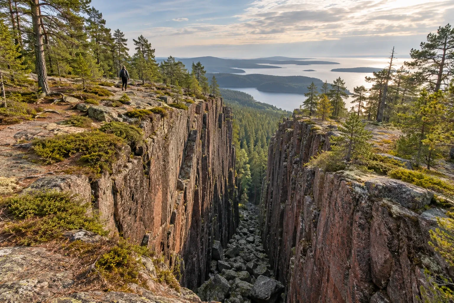
Skuleskogen packs steep forest, bare rock, sandy coves and a famous crevice into a small coastal park. Here is which entrance to use, what the park’s regulation actually says, and why the classic walk through Slåttdalsskrevan is over.
When you need this
You want to see Slåttdalsskrevan on a day trip and need to know where to park and how far it is. Or you plan a night in one of the free cabins, have a dog or a pushchair with you, or are coming by bus. This page covers the park itself. For the multi-day route that crosses it, see the High Coast Trail; for Skuleberget, the islands and the wider region, see the High Coast.
The park at a glance
Skuleskogens nationalpark sits on the Gulf of Bothnia, east of the E4 between Örnsköldsvik and Härnösand. It was formed on 10 May 1984, extended in 2009, and covers 3,062 hectares. The state agency Naturvårdsverket owns the land and the county board, Länsstyrelsen Västernorrland, manages it. It is one of Sweden’s 31 national parks, a Natura 2000 site and part of the High Coast / Kvarken Archipelago World Heritage site.
The government’s stated purpose is to keep a steep coastal landscape of forest, bare rock and rift valleys untouched, so that plants and animals develop freely. On the ground that means old spruce in the ravines, sparse pine on hällmark (bare rock slabs), small lakes and bogs, and about 13 km of sea shore. The oldest shoreline lies about 282 m above today’s sea, and you walk past klapperfält, fields of round stones the sea left behind as the land rose.
Expect roughly 30 km of marked trails. The county board says more than 30 km; the management plan counts an 8.7 km coastal path plus about 19 km of other paths. The park’s own accessibility page warns that many experienced hikers find these trails unusually challenging, so a short distance on the map can still fill a day.
Slåttdalsskrevan: what changed in 2023
Slåttdalsskrevan splits the hill Slåttdalsberget in two: a crevice about 200 m long and 7 m wide. Official pages give its depth as 30 m, 30–40 m or “40 m high vertical walls”, depending on the page. It began 1,200 million years ago, when magma filled a crack in the bedrock and set as diabase. The diabase weathered faster than the granite around it, and ice ages, sea and land uplift slowly emptied the crack.
You should no longer walk through it. The park’s management plan was revised on 23 March 2023: stones and blocks risk falling into the crevice and are a safety risk to visitors, so the trail is being moved into a loop past the crevice, letting you see it from above and below without passing through. Naturkartan’s page for the High Coast Trail stage through the park now says the crevice is no longer recommended to pass through because of rockfall risk. Many blogs and videos still show people walking the floor of the crevice — they predate this.
This is advice from the park’s managers, not a line in the park regulation. But mobile coverage is weak in the park, so an accident here is a long way from help. Take the viewpoints instead: the plan places them on Slåttdalsberget north and south of the crevice, the park recommends the “detour” over the hilltop for the widest view of the High Coast, and a rise northwest of the crevice makes a good coffee stop.
Which entrance?
The park has three entrances, each with a car park, information deck and toilet. Distances below are one way, from the park’s own pages.
| Entrance | Getting there by car | To Slåttdalsskrevan | Also from here |
|---|---|---|---|
| Entré Syd (South) | E4 about 2 km north of Docksta, turn opposite the naturum road, then 8 km | about 3.5 km | Kälsviken beach; Näskebodarna 3.8 km; Tärnättholmarna 5.5 km |
| Entré Nord (North) | Leave the E4 at Bjästa, about 25 km south of Örnsköldsvik, via Köpmanholmen and Näske | about 4.5 km | Tärnättholmarna 3 km; Salsviken’s beach |
| Entré Väst (West) | E4 about 5 km north of Skuleberget, then 3 km up a signed road | about 6 km (demanding) | Accessible viewpoint 600–700 m; Skrattabborrtjärn 2.7 km |
Entré Syd is the shortest way to the crevice and the busiest entrance; the management plan says most crevice visitors start here. It has benches but no fire place — the nearest is at Kälsviken’s beach, with wind shelters and firewood. Mobile coverage is especially poor here.
Entré Nord suits a coastal day. A short detour up Krypenbranten shows långskägg, a rare hanging lichen on old spruces, and the tent site at Salsviken’s outlet has its own sandy beach.
Entré Väst is the highest start, over open rock slabs with long views. The route to the crevice is the park’s own “demanding” grade, and it is a fine snowshoe route in winter.
The easiest trail in the park is Kuststigen, the coastal path between Entré Syd and Entré Nord. It is less hilly and suits dogs and smaller children. The hardest is the path from Tärnättvattnet to Tärnättholmarna via the cave: very steep, unsuitable to walk down, and to be avoided in wet weather and with dogs or small children.
The rules
Skuleskogen’s rules are a binding regulation, NFS 2009:4, and breaking it is punishable by fines under the Environmental Code. As in all parks, it limits allemansrätten, the right of public access.
| Activity | Rule | Type |
|---|---|---|
| Tent | 1 May–30 September: only at designated places, max three nights in one spot; longer needs a county permit | law |
| Fire | 1 May–30 September: only at designated fire places, with wood you bring or that is provided | law |
| Firewood, all year | Do not break branches or gather wood from the ground | guidance; damaging trees is law |
| Dog | Always on a lead | law |
| Cycling | Only on Kuststigen between Entré Syd and Entré Nord | law |
| Drone | No landing aircraft; the park says this includes drones | law |
| Fishing and hunting | No fishing in lakes, tarns and streams; no hunting | law |
| Vehicles | No motor vehicles or jet skis; snowmobiles may cross the sea ice | law |
| Plants and wildlife | No picking mosses, lichens or wood fungi, digging plants, damaging trees, or disturbing wildlife | law |
| Riding, events | Need the county board’s permit | law |
The season matters. The tent and fire limits apply only from 1 May to 30 September. Outside that period the regulation does not restrict where you pitch, and the park says fires may be lit elsewhere in the park — though the year-round rules on trees and wildlife still apply. A county fire ban always overrides the park’s fire places. The county board can grant an exemption from the regulation in an individual case for special reasons. For drone rules beyond the boundary, see drone rules in Sweden.
Sleeping in the park
The park has six simple overnight cabins and one rest cabin. They are open all year, free, and cannot be booked. Each has bunks with mattresses, a wood stove, a table and chairs; bring a sleeping bag, pillow, cooking gear and ideally a gas or spirit stove. You may stay two nights at most, and anyone who has slept a night must give way to new arrivals.
Dogs may stay in the cabins but not on the beds. Chop and refill the firewood before you leave, take all rubbish out, and leave no food, which attracts mice. In winter the newest cabins — at Skrattabborrtjärn, Näskebodarna and the large one on Tärnättholmen — are the easiest to heat.
Two large shelters with flat floors, at Tärnättholmarna and by Lill-Rutenstugan, are meant for sleeping; bring a pad. Tent sites are next to every overnight cabin and on the beaches at Kälsviken and Salsviken, marked as yellow dots on the park map. Näskebodarna, an old summer farm 3.8 km from Entré Syd, has a four-bed cabin and tent sites; the cottages just north of it are private.
Getting there
By train, travel to Härnösand or Örnsköldsvik and continue by bus. Line 50 between Härnösand and Örnsköldsvik runs on weekdays only. It stops at Skuleskogen Entré V E4, 3 km below Entré Väst, and at Naturum Höga kusten E4, about 10 km from Entré Syd on foot. Local lines 421 and 422 serve Näske, about 3 km from Entré Nord. Single tickets are paid by bank card on board or in the Din Tur app.
Naturum Höga Kusten, the visitor centre at the foot of Skuleberget, is about 10 km from Entré Syd and Entré Väst. It has exhibitions on the park and the World Heritage site, drinking water and a café, and opens from March to November. For planning the train and bus legs, see Sweden without a car.
Accessibility
All three entrances have wooden ramps to large information decks, covered benches and composting toilets adapted for wheelchair users; Entré Väst and Entré Nord also have grill places. From Entré Väst, an accessible path of about 600–700 m leads to a viewpoint on Nylandsruten. The park recommends it for wheelchairs and pushchairs.
At Entré Syd, holders of a disabled parking permit can borrow a key at naturum Höga Kusten to drive a barrier road to two parking spaces near Kälsviken. From there a wide gravel path reaches an accessible wind shelter, grill place and toilet. Arrange the key in good time and collect it during naturum’s opening hours. The decks and ramps are not cleared of snow in winter.
Season by season
| Season | What to expect |
|---|---|
| Spring | Fewer visitors and full streams; snow can lie into May, especially at Entré Väst |
| 1 May–30 September | Tents and fires only at designated places |
| Summer | Busiest; weather from hot to cold, wet and windy; streams can dry up |
| Autumn | Colours and fewer visitors; colder, wetter, shorter days |
| October–April | Park tent and fire limits lapse; fire bans and tree rules still apply |
| Winter | Fewest visitors; skis or snowshoes may be needed; summer trail markings can vanish under snow |
The park is home to the Siberian jay, cranes, black-throated divers, several woodpeckers and grey seals offshore. Bears, beavers and lynx tracks turn up rarely. People hunted and fished here as early as 1500–500 BC and left large Bronze Age cairns; later, the forest was such a barrier that it still marks the border between Kramfors and Örnsköldsvik municipalities.
Practical information
| Item | Detail |
|---|---|
| Entry | No entry fee mentioned on the official pages |
| Cabins, shelters, tent sites | Free; cannot be booked (checked 2026-10-14) |
| Parking | Free at the entrances (checked 2026-10-14) |
| Water | No taps at the entrances or in the park; stream water untreated — boil if unsure |
| Food | Nothing sold in the park; café and water at naturum |
| Rubbish | No bins in the park; sorting bins at the entrances |
| Mobile coverage | Not in the whole park; especially poor at Entré Syd. Emergency: 112, works without a SIM |
| Bus line 50 | Weekdays only (checked 2026-10-14); times and fares on Din Tur |
| Naturum Höga Kusten | Open March to November |
| Cabin status | County board: all cabins open (checked 2026-10-14) |
FAQ
Can you walk through Slåttdalsskrevan?
You should not. The park’s management plan, revised in March 2023, says stones and blocks risk falling into the crevice and are a safety risk, so the trail is being rerouted as a loop that lets you see the crevice from above and below without passing through. Naturkartan’s trail page says the crevice is no longer recommended to pass through.
How far is Slåttdalsskrevan from the parking?
About 3.5 km from Entré Syd, 4.5 km from Entré Nord and 6 km from Entré Väst, one way, according to the national park’s own page. Entré Syd is the shortest and most used start. The terrain is steep and rocky, so plan on several hours for the return walk and carry water, because there is none at the entrances.
Can you camp in Skuleskogen National Park?
Yes, with limits. From 1 May to 30 September you may pitch a tent only at designated places, marked as yellow dots on the park map, and for at most three nights in one spot. Tent sites are by every overnight cabin and on the beaches at Kälsviken and Salsviken. Outside that period the regulation’s tent limit does not apply.
Are the cabins in Skuleskogen free?
Yes. The park has six simple overnight cabins and one rest cabin, open all year, free of charge, and they cannot be booked. You may stay two nights at most, and someone who has already slept a night must give way to new arrivals. Bring a sleeping bag, pillow and cooking gear, and refill the firewood before you leave.
Can I bring my dog to Skuleskogen?
Yes, on a lead at all times; the park regulation bans unleashed dogs. Dogs may stay in the overnight cabins but not on the beds. The coastal path between Entré Syd and Entré Nord suits dogs best; avoid the steep path from Tärnättvattnet to Tärnättholmarna via the cave, and bring water for the dog.
How do you get to Skuleskogen by bus?
Bus line 50 between Härnösand and Örnsköldsvik, which runs on weekdays only, stops at Skuleskogen Entré V E4, 3 km from Entré Väst, and at Naturum Höga kusten E4, about 10 km from Entré Syd. Local lines 421 and 422 serve Näske, about 3 km from Entré Nord. Trains run to Härnösand and Örnsköldsvik.
Is Skuleskogen accessible with a wheelchair?
Partly. All three entrances have wooden ramps to information decks, covered benches and wheelchair-adapted composting toilets. Entré Väst has a path of about 600 m to a viewpoint. At Entré Syd, permit holders can borrow a key at naturum to drive to Kälsviken. The ramps are not cleared of snow in winter.
Related guides
- The High Coast Trail — the nine-section route that crosses the park, with buses and overnight stops
- The High Coast — Skuleberget, Ulvön and the rest of the World Heritage coast
- Sweden’s national parks — how all 31 parks’ rules override allemansrätten
- Wild camping in Sweden — tent rules once you leave the park
- Fulufjället and the Njupeskär Waterfall — another park where a gorge trail has safety limits
Facts verified 2026-10-14. Sources: Naturvårdsverket (park regulation NFS 2009:4, management plan, Sveriges nationalparker), Sveriges riksdag (nationalparksförordningen, Environmental Code), Länsstyrelsen Västernorrland, Naturkartan, Din Tur — full register in this topic’s source file. Found something outdated? Tell us and we’ll fix it.